Rangitahi Lake
Appearance
| Rangitahi Lake | |
|---|---|
 Lake Rangitai | |
| Location | Chatham Island, Chatham Islands |
| Coordinates | 43°46′S 176°21′W / 43.767°S 176.350°W |
| Basin countries | New Zealand |
| Surface area | 867 ha (2,140 acres) |
| Max. depth | 1.3 m (4 ft 3 in) |
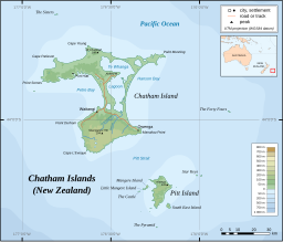
Rangitahi Lake (sometimes spelt Rangitai)[1] is located in the Chatham Islands of New Zealand. It is located on Chatham Island, to the northeast of Te Whanga Lagoon, close to the northern end of Hanson Bay.
Lake Rangitai is a dune-dammed lake, which is clearer than nearby lakes, with underwater visibility over 10 m (33 ft). It provides the water supply for Kaingaroa,[2] about 6 km (3.7 mi) away.[3] In the deeper parts of the lake the vegetation is dominated by the Charophytes Lamprothamnium and Nitella hyalina.[2]
References
[edit]- ^ "Lake Rangitai, Chatham Islands". NZ Topo Map. Retrieved 27 November 2020.
- ^ a b Paul D. Champion and John S. Clayton (March 2004). "Aquatic vegetation of Chatham Island (Rekohu)" (PDF). Department of Conservation.
- ^ "Kaingaroa, Chatham Islands". NZ Topo Map. Retrieved 27 November 2020.


